In Depth
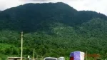
The range is geographically significant because it separates the Longai Valley to the north from the Chargola Valley to the south. Its highest hill is commonly reported to be around 1,500 feet above sea level, rising above the relatively level surrounding landscape. This elevated terrain creates attractive views of the valleys, nearby settlements and green countryside.
Natural Landscape and Scenic Views
Duhalia Range is characterised by rolling hills, wooded slopes and stretches of rural agricultural land. Forest vegetation, rubber plantations and nearby tea estates contribute to the area's varied green landscape. Depending on the season and weather, visitors may see layers of hills, open valley views and cultivated fields stretching into the distance.
The roads passing through the surrounding countryside offer opportunities to appreciate the landscape at a relaxed pace. Some elevated stretches provide suitable locations for photography and short stops, although visitors should choose safe places to park without obstructing local traffic. The quiet environment makes the range particularly appealing to people looking for a break from busy town life.
Trekking, Hiking and Outdoor Activities
Walking and light trekking are among the activities that may interest visitors to Duhalia Range. Rural paths and forest tracks pass through parts of the hilly terrain, offering opportunities to explore the natural surroundings. However, these should not automatically be treated as established or maintained tourist trekking routes. Local guidance is useful before entering unfamiliar trails.
Birdwatching is another possible activity for nature enthusiasts. The wooded areas provide habitat for local birdlife and other small wildlife, although sightings depend on the season, weather and location. Visitors interested in wildlife observation should maintain a respectful distance, avoid disturbing animals and refrain from littering.
The range is also suitable for a quiet day trip, nature photography and enjoying the countryside. Rather than expecting organised adventure facilities, travellers should approach the destination as a largely rural natural landscape.
Villages and Rural Life Around the Hills
Small settlements and agricultural areas are scattered around the Duhalia Range. These villages offer a glimpse of everyday life in the Barak Valley, where farming and plantation activities form part of the local landscape. Travelling through the surrounding countryside can be an opportunity to appreciate the region's rural character and the relationship between its communities and natural environment.
Visitors should respect private land, plantation boundaries and village customs. If planning a longer walk or photography session near a settlement, asking local residents for guidance is a considerate approach.
Best Time to Visit Duhalia Range
October to February is generally a comfortable period for exploring the hills, as the weather is cooler and outdoor movement is usually easier during the drier months. The greenery can be particularly attractive after the monsoon, although trails and rural roads may remain muddy.
During the rainy season, heavy showers can make forest paths slippery and some road sections difficult to negotiate. Visitors should check local weather and road conditions before travelling. Daytime visits are preferable, especially for anyone unfamiliar with the area.
Where to Stay and Food Options
There are no established commercial hotel or resort facilities described within the Duhalia Range itself. Sribhumi town (Karimganj) and Badarpur can serve as practical accommodation bases, while Patharkandi and nearby villages may offer other local options. Confirm availability and facilities directly before setting out.
Restaurants and shops may be limited in the hilly areas. Carry sufficient drinking water, snacks and food for the duration of your visit. Overnight camping or village homestays should only be considered after confirming permission, safety and arrangements with local residents or relevant authorities.
How to Reach Duhalia Range from Guwahati
By Air: The nearest major airport is Kumbhirgram Airport near Silchar. It is approximately 83–85 km from Sribhumi town, from where visitors can arrange a taxi or other local transport towards the Duhalia Range.
By Train: Badarpur Junction and Karimganj Junction are the principal railway stations for reaching the district. Patharkandi Railway Station and Baraigram Junction may also be useful depending on the intended starting point and available train services. From the railway station, hire a local vehicle to reach the foothills or nearby villages.
By Road: Sribhumi is connected with other parts of Assam through the regional highway network. Travellers from Guwahati can reach the district by road, while Silchar offers regular regional transport connections. Once in Sribhumi town or Patharkandi, arrange a local taxi or suitable vehicle for the onward journey. The final approach may involve rural roads and walking along uneven paths. A local guide can help identify accessible routes.
Travel Tips for Visitors
Duhalia Range is best approached as a nature outing rather than a fully developed tourist destination. Carry water, food, suitable walking shoes and basic essentials. Mobile connectivity may be unreliable in some remote stretches, so inform someone about your route and expected return time. Avoid entering dense forest areas alone, respect local land and plantation boundaries, and take all waste back with you.
Why Visit Duhalia Range?
For travellers exploring Sribhumi district, Duhalia Range offers a different experience from the region's temples, historic sites and riverside picnic destinations. Its green hills, valley landscapes and quiet rural surroundings make it worth considering for a peaceful day trip, nature photography or a short outdoor walk. If you enjoy discovering less-commercialised destinations, the Pratapgarh hills provide an opportunity to experience another side of Assam's Barak Valley.