


About Darrang District
Darrang is an administrative district in the state of Assam in India. The district headquarters are located at Mangaldai. The district occupies an area of 3481 sq.km. The District of Darrang (undivided) had been created with effect from July'1983 converting the erstwhile Sub-Division of Mangaldai. Recently this District has been divided into Udalguri District (under BTAD) & Darrang District. The Udalguri District covers the major portion of this undivided Darrang District. This literature & website however, still covers the undivided District. The word Darrang would mean undivided form of the District from this point & further.This district covers an area of approximately 3481 sq km. Darrang District shares the border with Bhutan and Arunachal Pradesh. People of various communities live here with peace and harmony. Darrang District is in the central part of Assam.
The name Darrang was derived from the Bodo word Dourang, which means 'Lilabhumi' (Playground) of Gods. According to Scholar Late Dineswar Sarma, the word Darrang came from Dawrang which means gate, as there was direct entry to Bhutan and from there to Nepal, China etc. Gradually this was know as Darrang.
Darrang consists of a narrow strip of plain lying between Himalayas and Brahmaputra river in the north-west part of Assam. The land which is now known as Darrang district was included in the Hindu Kingdom of Kamrupa as mentioned in Mahabharata. Its antiquity dates back to the beginning of the sixteenth century when the Koch King Nar Narayan incorporated this district in his Kingdom. In 1637, the Ahom Kingdom was established in the land after the death of the then Koch King Bali Narayana. In 1792, Darrang Raja was defeated by an expeditionary force under the command of Captain Welsh and in 1826. Darrang with rest of Assam passed under the British rule. The existing Darrang district was formed on 1st July,1983 comprising of two Subdivisions viz., Mangaldai and Udalguri, with the district headquarter at Mangaldai. The important towns in Darrang are Udalguri, Tangla, Rowta, Kharupetia. After the formation of Bodoland Territorial Areas District (BTAD), Udalguri has been turned into a district, encompassing a large area, including Bhairabkund, Rowta, and Orang, etc. Udalguri has every potential to be the nerve center of the newly formed BTAD. Sudempuri, is one of the rapidly developing part of Udalguri district, followed by Maidanguri and others. Kalaigaon is also an important place of this district. People of different communities live with peace and harmony here; the total population of which 868,532[citation needed] (57.74%) are Hindus, 534,658[citation needed] (35.54%) are Muslims, and 97,306[citation needed] (1.75%) are Christians.
Economy
The economy of the Darrang district is basically agrarian where the majority (about 85% ) of the population is engaged in agriculture and allied activities. Out of the total population of 12,98,860 in the district only 4,05,743 (i.e. 31.23 %.) constitute the workforce. Agriculture is the main source of income of the people in this district. Moreover, Sericulture in Darrang district is an age old industry. It helps as a part time occupation to a huge mass of economically weaker section of the society residing in the rural area of the region. Thus, sericulture has gathered a considerable importance in the socio-economic life of the society. Production of fish in the district is quite negligible. Tea is the only plantation crop of this district. Sericulture in Darrang district is an age old industry. It helps as a part time occupation to a vast majority of economically weaker section of the society of rural area.. Therefore sericulture has gathered a considerable importance in the socio-economic life of the society.
Tea is the only plantation crop of the district. However, late steps are being taken to cultivate rubber and Citronella also. There are 28 Nos. of Tea Gardens in the District covering an area of 11,625.56 hectares. Annual production of Tea is registered to be around 23.1 million kg. The tea industry of the district engages around 66,158 persons.
There were altogether 75 Nos. of registered factories in the district in 1995. In addition to these, there as many as 845 small industrial units registered up to 1996 under the Industries Department in the district. In the district the main polyester industry is the Prag Bosimi Synthetics Ltd. located at Sipajhar which employs a large number of skilled and unskilled labour. Besides there are a few tea factories in the district. In the district the need of the hour is setting up of the Jute Mill at Dalgaon where it is technically and economically viable.
Attraction:
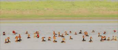
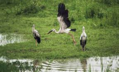
ORANG NATIONAL PARK : Orang Sanctuary, Also termed as a miniature Kaziranga, is located near Silbori, and on the north bank of river Brahmaputra. It covers an area of 78 sq. km.It is famous for One horned Rhinoceros, Royal Bengal Tiger, Barking Deer, Elephant, Leopard, Sambar and Hogdeer, Pangolin, Civet Cat & Otter,Both migratory and local birds. viz. Palican, Green Pigeon, Bengal Florican, Cormorant, Greylag Goose, Large Whistling Teal, Great Adjutant Stork, King Vulture. Orang is at a distance of 140 kms. from Guwahati, 32 kms. from Tezpur and 68 kms. from Mangaldai, the district HQ by road. It would take One and half hour to reach from Mangaldai. The nearest railhead is Rongapara and the nearest airport is Saloni (Tezpur).Public buses & rental cars are available from Guwahati, the State Capital or Mangaldai.
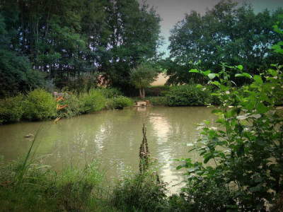
Batha Beel:A nice opportunity for bird watchers, thousands of migratory birds come to this beel. It is near Hazarikapara (Sipajhar)
Pukhuria Beel:Another choice for Bird watchers. Hundreds of migratory birds come to this beel every year.
Baladev Pukhuri:Located at Baldevpara, west of Sipajhar, is a beel covering 48 Bighaas was created during the reign of King Dharma Narayana. Today, it is serving as Govt. Fishery.
Jaypal Pukhuri:A huge Pond, with an area of 20 Bighaas at Barkaliyajhar village known to be created during the reign of King Jaypal. The water of this pond is crystal clear and stays above ground level!
Bhairavkunda of Udalguri Subdivision is a famous pilgrim center. The village Patharughat of this district is famous for the historic event of 1894, when firing by British administration claimed lives of more than 15 villagers while they were in protest against the enhancement of land revenue and imposition of local rates. Prag Bosimi Synthetics Limited, a joint sector undertaking of Government of Assam and Bombay Silk Mill with foreign collaboration is also an important asset of the District.
Gandhi Smriti Park: Located in the heart of the Mangaldai town & within walking distance from DC's Office, this is a very well maintained & beautiful park.
Patharughat Swaheed Minar:There is a swaheed minar in a beautiful park in the Jalliwanwalabag of Assam.
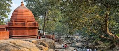
Kamakshya Devalaya:To the south-west of Kalaigaon, near Lakhimpur village, is this Devalaya. There is a Stone fetish inside the temple with 8 lotus petals on it. Doul Festival - the religious part of the Holy Festival is celebrated here in Spring. It was founded before 12th century AD and favoured by Ahom& Koch Kings.
Thaans are another kind of place of worship. Usually triggered by some fetish e.g., some old tree or stone etc., afterwards often transformed into place of institutional worship.
Banks in Darrang District :
1) Central Bank Of India, B/O. NAMKHOLA, P.O. SIPAJHAR, Phone : 03713) 266687
2) Central Bank Of India, P.O.AULACHOWKA,VIA MANGALDOI, Phone : (03713) 262003
3) Central Bank Of India, B/O. BURHA, AT VILLAGE DUMANI CHOWK, P.O. MARUA CHOWKI, Phone : (03713) 264183
4)State Bank of India, Mangaldai-03713-222139
5)UCO Bank,03713-222152
6)P.G. Bank,03713-222220
7)Apex Bank,03713-222108
8)Central Bank,03713-222253
9)Nagar Samabai Bank,03713-222343
Banks ATMs in Darrnag District :
1) Axis Bank ATM, Ward No.5, New Police Station, Mangaldoi
