
About West Karbi Anglong District
West Karbi Anglong district is one of the hill districts of Assam, carved out to strengthen administrative efficiency and promote focused development in the western part of the Karbi Anglong plateau. Officially created in 2016, the district is known for its scenic hills, dense forests, flowing rivers and deep-rooted indigenous Karbi culture. Hamren, the district headquarters, serves as the administrative and cultural hub of the region.
Formation and Historical Background
The district was formed by bifurcating the western part of the undivided Karbi Anglong district. This administrative reorganization was undertaken to bring governance closer to the people living in remote hill areas. The region has a long history associated with the Karbi tribe, one of the oldest indigenous communities of Northeast India.
Before colonial rule, the Karbis lived in autonomous village units governed by customary laws and clan councils. During British administration, the area was known as the Mikir Hills. After Independence, it came under the Sixth Schedule of the Indian Constitution, ensuring protection of tribal land, culture and self-governance through the Karbi Anglong Autonomous Council (KAAC). West Karbi Anglong continues to function under this autonomous framework.
Geography and Natural Features
West Karbi Anglong lies in central Assam and shares borders with Morigaon, Nagaon, Hojai, Dima Hasao and the state of Meghalaya. The district features undulating hills, narrow valleys and forest-covered slopes. The Kopili, Borpani and Amreng rivers are important water bodies, supporting agriculture and local livelihoods.
The climate is moderate, with heavy monsoon rainfall and cool winters. Due to its hilly terrain, the district is prone to landslides during the rainy season, but the natural landscape also makes it rich in biodiversity and forest resources.
Population and Culture
The population of West Karbi Anglong is predominantly tribal. Karbis form the majority, along with Bodos, Dimasas, Tiwas, Garos, Khasis and other communities. Assamese, Karbi, Hindi and English are commonly spoken.
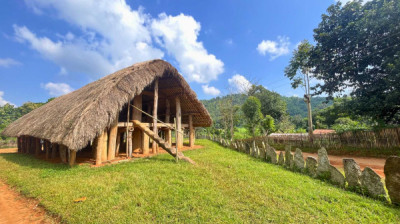
Traditional Karbi culture is deeply connected to nature, agriculture and festivals. Rongker, Chomangkan and other indigenous celebrations reflect ancestral beliefs and social harmony. Music, dance and woodcraft remain integral to community life.
Economy and Livelihood
Agriculture is the backbone of the district economy. Most residents depend on subsistence farming, with rice, maize, ginger, vegetables and pulses as major crops. Shifting cultivation or jhum is still practiced in interior areas, though efforts are being made to introduce settled agriculture and horticulture.
Forest-based livelihoods play an important role. Collection of bamboo, cane, broom grass and other minor forest produce supplements household income. Small-scale mining of sand and stone from riverbeds contributes to local revenue, though environmental regulation is essential.
Industrial development is limited, but government schemes focus on skill development, self-help groups, organic farming and rural entrepreneurship.
Tourism Potential
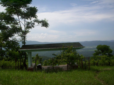
West Karbi Anglong is an emerging eco-tourism destination. The district offers unspoiled landscapes, waterfalls, forest trails and cultural experiences.
Key tourist attractions include:
-
Baithalangso hill area: Nestled amidst rolling green hills, dense forests, rivers, and tribal villages, this charming town offers visitors a refreshing escape from crowded tourist spots.
-
Umswai Valley: Umswai Valley is one of the most fascinating and culturally rich destinations in Assam, located in the picturesque West Karbi Anglong district. Surrounded by forest-covered hills, traditional tribal villages, fertile farmlands, and breathtaking landscapes, the valley offers visitors a unique blend of nature, culture, history, and sustainable tourism.
-
Tika Hills: Tika Hills is a culturally and historically significant hill range located in the Donka Circle of West Karbi Anglong District, Assam. Rising roughly 24 km from the town of Hamren, the district headquarters, the hills are celebrated for their natural, unpolluted environment, panoramic views of the region, and rich tribal heritage
-
Kopili River stretches
-
Traditional Karbi villages
Tourism remains low-impact and community-based, making the district ideal for travelers seeking peace and cultural immersion.
Transport and Connectivity
Road transport is the primary mode of connectivity. While there is no railway line or airport within the district, ongoing road development projects aim to improve access to remote villages. Hamren is well connected to Diphu, Nagaon and Guwahati by road.
Administration and Governance
The district administration functions under the Karbi Anglong Autonomous Council, ensuring protection of tribal rights and land ownership. The Deputy Commissioner coordinates development, disaster management and welfare programs in coordination with KAAC.
Importance of the Diastrict
West Karbi Anglong plays a vital role in preserving Assam's hill ecology and tribal heritage. Its formation has helped improve governance, healthcare access and infrastructure in previously underserved regions. With sustainable development and eco-tourism initiatives, the district holds strong potential for inclusive growth.