|
|||||||||||||||||||||
|
| HOME » DISTRICTS » KARIMGANJ |

|

|
KARIMGANJ DISTRICT |
|||||||||||||||||||||||||||||||||||||||||||
|
|
|
|||||||||||||||||||||||||||||||||||||||||
|
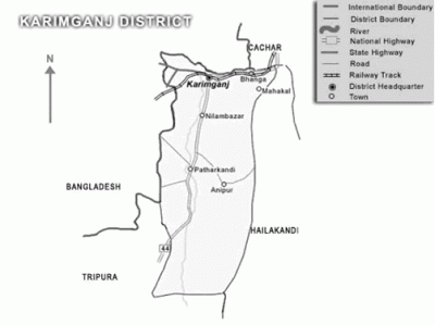
Karimganj District is an administrative district in the state of Assam. The district occupies an area of 1809 sq. km. It is bounded on the northeast by Cachar District, on the east by Hailakandi District, on the south by Mizoram state, on the southwest by Tripura state, and on the west and northwest by Bangladesh. Karimganj Town, the administrative headquarter and main town of the district also bears the same name, that is, Karimganj. Together with two other neighboring districts - Cachar and Hailakandi - it constitutes the Barak Valley zone in Southern Assam. Karimganj town is located on the northern fringe of the district adjoining Bangladesh, by the river Kushiyara. Its distance from Guwahati - the state capital of Assam - is approximately 330 km by road and about 350 km by rail. Distances of other important places are : Silchar - 55 km, Shillong - 220 km, Agartala - 250 km. Flanked on two sides by the rivers Kushiyara and Longai, Karimganj town is located just on the Bangladesh border with the river Kushiyara flowing in between. One prominent feature of the place is a long and winding canal called Noti Khal meandering through the town. Earlier, it used to be a connecting river way between Kushiyara and Longai facilitating river communication and also balancing of water-levels between the two rivers. Now, however, this canal has been blocked at several places through embankments and land-fills to pave way for road transport and construction works.Latu is one of the historically interesting village of Karimganj. | |||||||||||||||||||||||||||||||||||||||||||
| :: MAJOR TOWNS IN KARIMGANJ :: | |||||||||||||||||||||||||||||||||||||||||||
|
Karimganj, Badarpur, Badarpur Rly Town T.C. | |||||||||||||||||||||||||||||||||||||||||||
| :: BLOCKS and SUBDIVISIONS IN KARIMGANJ :: | |||||||||||||||||||||||||||||||||||||||||||
|
Karimganj | |||||||||||||||||||||||||||||||||||||||||||
| :: LEGISLATIVE ASSEMBLY SEATS IN KARIMGANJ :: | |||||||||||||||||||||||||||||||||||||||||||
|
1) Ratabari (SC) - Kripanath Mallah (BJP ) | |||||||||||||||||||||||||||||||||||||||||||
| :: HOSPITALS IN KARIMGANJ:: | |||||||||||||||||||||||||||||||||||||||||||
|
1) Karimganj Civil Hospital, Phone : 03843-263200, Mobile: +91-9864030346, | |||||||||||||||||||||||||||||||||||||||||||
| :: POLICE STATIONS IN KARIMGANJ:: | |||||||||||||||||||||||||||||||||||||||||||
|
Name of the S. P. - Shri Pradip Ranjan Kar, APS | |||||||||||||||||||||||||||||||||||||||||||
| :: HOW TO REACHED KARIMGANJ FROM GUWAHATI(CAPITAL) :: | |||||||||||||||||||||||||||||||||||||||||||
|
From sate capital Karimganj is near about 338 Kms. The major road link to the district is National Highway 44 which starts from Shillong in Meghalaya and after passing through Karimganj, goes upto Agartala in Tripura state. It also provides a major intra-district communication backbone as it covers a stretch of more than 83 Kms in this district. After entering through Karimganj-Hailakandi border at Badarpurghat, it connects important places like Badarpur, Karimganj Town, Nilambazar, Patherkandi, Lowairpoa etc, before entering Tripura at Churaibari. Road link to the nearest major town Silchar is provided by N.H. 53. Besides, a new National Highway 151 has been sanctioned for connecting Karimganj Town with Sutarkandi on the Bangladesh. This is largely meant to facilitate border trade with Bangladesh by road. | |||||||||||||||||||||||||||||||||||||||||||
| :: RAILWAY STATIONS IN KARIMGANJ :: | |||||||||||||||||||||||||||||||||||||||||||
|
In earlier times, rail communication used to be the most preferred mode of communication both for passenger and cargo. In the pre-independance era, Karimganj Railway station was a major hub of rail communication as the whole of Assam and present day North-east was connected by a major rail link passing through present day Bangladesh. After independance of India, which was accompanied by partition of the land, the main rail link was sealed and Karimganj railway junction lost much of its importance. Even now, a train service is operated through this truncated rail-link from Karimganj Junction to the border station of Mahishasan which is just at a distance of 12 Kms. | |||||||||||||||||||||||||||||||||||||||||||
| :: AIRPORTS IN KARIMGANJ :: | |||||||||||||||||||||||||||||||||||||||||||
|
Karimganj district does not have its own airport. However, the nearest airport at Kumbhirgram (near Silchar - in cachar district) at a distance of 83 Kms. from Karimganj town (48 Kms. from Badarpurghat) serves as the major communication link point for the people of Karimganj. Indian Airlines (Alliance Air) operates flight services in the Silchar-Calcutta (6 days per week) and Silchar-Imphal (3 days per week) routes from this airport. | |||||||||||||||||||||||||||||||||||||||||||
| :: SOME OTHER CONTACTS OF KARIMGANJ :: | |||||||||||||||||||||||||||||||||||||||||||
|
1) Deputy Commissioner - 262345(O)/262103(R) | |||||||||||||||||||||||||||||||||||||||||||
| :: DISTRICTS PIN CODES OF KARIMGANJ :: | |||||||||||||||||||||||||||||||||||||||||||
|
Adarkona 788701 | |||||||||||||||||||||||||||||||||||||||||||

|

|
| HOME | | | DISTRICTS | | | TOURIST PLACES | | | CULTURE | | | FESTIVALS | | | EDUCATION | | | FAMOUS PEOPLES | | | ASSAMESE RECIPES | | | CLASSIFIEDS | | | CONTACT US | | | SITE MAP | ||||
| Copyright © 2025 www.assaminfo.com All Rights Reserved | ||||||||||||||||||||||||
